To view the Vestiges image gallery, please follow this LINK.
Place in Time: The Christchurch Documentary Project’s website will open in a new browser window. This gallery presents a distilled edit of the larger body of work.
The text below was written as an introduction to a forthcoming, short-run artist book. The making of this book marks an approximate half-way point in my long-term efforts to document the residential red-zoned suburb of Avonside, Christchurch, New Zealand, during a period of rapid change.
At 4:35am on September 4th 2010, Christchurch, New Zealand was hit by a magnitude 7.1 earthquake. Miraculously, despite it and thousands of aftershocks causing widespread damage to buildings and infrastructure across the city, there was no loss of life.
Avonside–a suburb measuring 1.3 square kilometres and home to over 3200 people–suffered large-scale damage, particularly as a result of flooding, land subsidence and liquefaction. Entire streets were covered in silt and raw sewerage and the area was without power or clean, running water. Testament to the spirit of the community that called Avonside home, neighbours banded together and helped each other get their lives back on track. Unfortunately, no sooner than the last wheelbarrow of silt had been carried off to landfill, Christchurch shook again.
It was 12:51pm, February 22nd 2011. Over 400,000 tons of liquefaction spurted up from cracks in the ground; buildings collapsed and 185 lives were tragically lost in what is now regarded as New Zealand’s largest peacetime disaster. On an international level, the total insured losses as a result of the 2011 Christchurch earthquakes (February 22nd and the June 13th aftershock combined,) have been estimated as second only in history to the Japanese, Tohoku earthquake and tsunami of 20111. According to the Reserve Bank of New Zealand, the total cost of the Christchurch rebuild is projected to be in excess of forty billion New Zealand dollars, with construction and associated recovery activities expected to extend well beyond the year 20202.
The days and months following the February earthquake dragged on forever. Disputes with insurance companies became all consuming, especially after residents of Christchurch’s badly affected eastern suburbs began hearing the words “Red Zone”. In staggered media releases, land constituting much of Christchurch was officially deemed unsuitable for rebuilding on without extensive remediation work and, considering continuing seismic activity, the infrastructure sustaining the community too difficult and uneconomical to repair. Over the years since, removal vans have parked in then pulled out of a little more than eight thousand suburban driveways, making way for the demolition trucks to roll slowly in.
Residential areas red-zoned extended along the Avon River corridor, Southshore, Brooklands and the Waimakariri areas of Kaiapoi, Pines Beach and Kairaki. For property owners in these areas, the government came up with a buyout offer3. The sum of the offer equaled the 2007/8 Government Rating Valuation4 for each property, which in most cases did not reflect market values immediately prior to the earthquakes, or always take into account betterment to land or buildings in the time after the valuation had been determined. In addition to this, with a housing and land shortage brought on by such a large amount of residential land being written off, the inevitable consequence of this process was a great many people who accepted the government offer suffered significant financial loss, not to mention a profound sense of grief. For those not eligible for the government offer–mostly due to lack of private insurance–or who refused to accept the terms, they were left at the mercy of the Christchurch City Council and Christchurch Earthquake Recovery Authority5, who were under no obligation to maintain or fix critical infrastructure and services on red-zoned land post the deemed settlement offer deadline.
The images contained within this book form a representative selection from my ongoing body of work, Vestiges. Following on from the project Thx 4 the Memories (2011–2013,) this short run publication marks an approximate halfway point in what has become a long-term obsession to document change in the red-zoned suburb of Avonside, tracking a relatively densely populated, suburban neighbourhood to pseudo-park and beyond. At the time of writing, there is debate as to what use, if any, the land that constitutes Avonside–or any residential red-zoned land–will eventually be put to, and how the government will want to recoup the $1.5 billion it spent acquiring it. It is speculated that there may be announcements of intention during the early part of 20176, but with a national election looming, most predict any meaningful information will be withheld until a later, less politically charged date.
Thx 4 the Memories was a project undertaken by myself, Glenn Busch and Bridgit Anderson as part of Place in Time: The Christchurch Documentary Project. At the invitation of Lawrence Roberts, Gail Ross and The CowPats–an Avonside residents group, their name an amalgamation of Cowlishaw and Paton Streets–we were initially asked to document, in photographs and within oral history texts, the close knit community that existed on two adjoining streets during a time of great unrest.
At the time of our first meeting with the CowPats, Cowlishaw Street and most of Paton Street were designated Orange Zone, meaning decisions regarding the fate of the area were yet to be made by the government, pending the results of extensive geotechnical and infrastructural remediation reports7. Neighbouring properties on Retreat Road had already been designated Red Zone, but the Ministry of Education had invested significantly in fixing buildings at Avonside Girls High School, located on the south side of Cowlishaw Street. Some members of the CowPats, particularly those who lived on the same side of the road as the school, saw this as a sign their properties would “go green”, while more sceptical members speculated about a government sanctioned land grab in order to expand the school’s grounds. What all of the CowPats did agree on, however, was that it was painful watching their community slowly dissipate; seeing many of their Retreat Road neighbours and friends pack up and leave, while they had no choice but to grin and bear it. With each passing day and no news from the government either way, even the most optimistic of them couldn’t help but start to feel resentful. Eventually all of Cowlishaw Street was red-zoned, while the majority of Paton Street green-zoned. The CowPats were forced to go their separate ways.
It was during this initial meeting that Glenn, Bridgit and I realised that while a potent project detailing aspects of community and post-quake life could be undertaken by documenting Cowlishaw and Paton Streets alone, we needed to expand our efforts to look at the wider suburb of Avonside. Our rationale was clear, in that we wanted to include and give voice to as broad a spectrum of experience, thoughts and feelings as possible. Our hope was by documenting an entire suburb we might create a comprehensive record, indicative of what people in other red-zoned suburbs had been and were still going through. Avonside encapsulated a relatively wide spectrum of social demographics, but beyond recording the social-political predicament that was playing out, a project of such expanded scope would also give a chance to make visible, over the course of many years, the built and natural landscape of a large patch of land as it slowly changed; its future long to be determined, but ghosts of the past lingering ever present.
Thx 4 the Memories formed a major part of the 2013 Christchurch Arts Festival. It took the form of a large, outdoor exhibition extending down Worcester Boulevard from the Arts Centre’s market square, past the Christchurch City Council building towards Cathedral Square. The exhibition was comprised of my photographs, oral history texts written by Glenn Busch and accompanying portraits of Avonside residents by Bridgit Anderson.
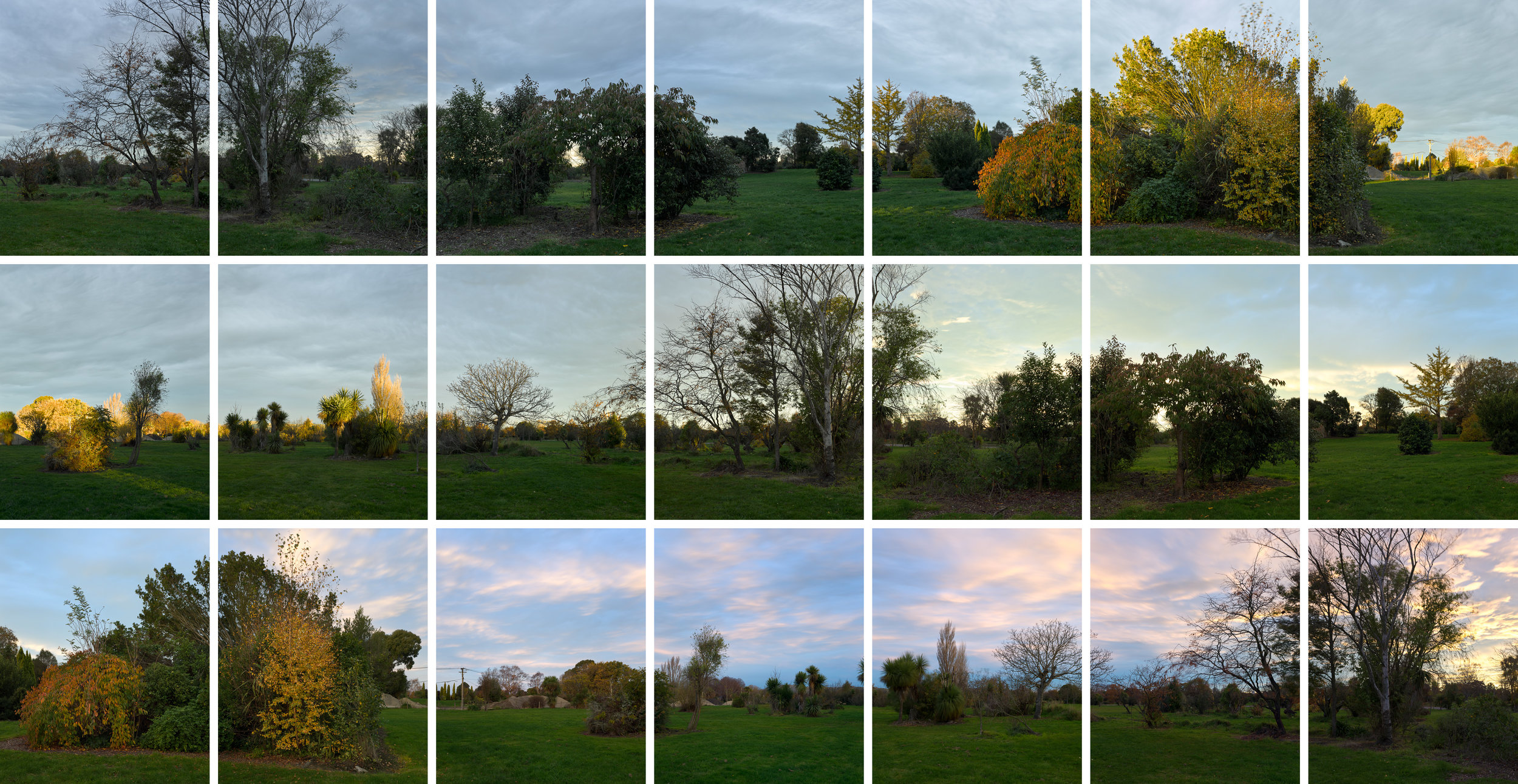
Vestiges is an independent project that continues on from where Thx 4 the Memories left off. Within Vestiges I am primarily concerned with trying to unpick concepts of time, proximity and memory. By photographing space as it opens up, and returning to certain sites and re-photographing them, over time my hope is to convey something of the psychology and history remaining within the land.
To this end, photographing in Avonside over the past five years has been a very disconcerting experience. Early on, one day a street would be full of life and most houses occupied. On such a day one might have been forgiven for thinking all was normal in this sleepy suburb. The next week, dust would hang in the air as machines demolished well-loved homes. Much of what was left of the well-established gardens was then thrown through wood chippers; graders scraped and levelled the earth and new grass was sown. Council workers now keep the grass from growing too long and periodically prune the remaining trees. With the vast majority of clearance work now finished, the area now feels unbearably quiet. Streets scarred with cavernous potholes and cracks still remain, but effectively they lead to nowhere. Roadblocks have been erected and fluorescent orange signs warn of access for authorised personal only. If you ignore the signs and take the time to stand in the landscape beyond them, cock your head and turn left then right, you can sense the ghostly shapes of buildings as they once stood. Avonside remains one of the oldest suburbs of Christchurch8, but if you don’t look you’ll miss it.
When looking at the photographs contained within this book I hope people are reminded of what has gone before, but more importantly are prompted to consider a narrative yet to be written. As natural forces and governmental decisions have dictated the recent history of Christchurch city, now that the Christchurch Earthquake Recovery Authority has wound up and Regenerate Christchurch has been established in its place, people must re-inhabit and lay claim to this patch of land as a place for all to use and enjoy. For while the vast majority of people who once lived in the Residential Red Zone no longer own the earth they once called home, it is their collective spirit and story we need to honour as we move forward, together.
Tim J. Veling
03-2017
1: Swiss Re Group, global reinsurer, released figures in 2012 that estimated economic losses due to the Christchurch earthquakes in 2011 as far behind Japan’s Tohoku earthquake and tsunami and flooding in Thailand, both of which occurred during the same year. However, the only higher earthquake-related insurance losses over the last 50 years resulted from Japan’s Tohoku earthquake and tsunami and the Northridge, California (USA) earthquake of 1994. Christchurch’s February 22nd and June 13th 2011 earthquakes combined resulted in insurance losses of approximately USD 17.2bn, which is more than double the initial (risk model based) estimates. See ‘Small quakes, big impact: lessons learned from Christchurch,’ http://www.swissre.com.
2: Reserve Bank of New Zealand ‘Bulletin’, Vol. 79, No. 3, February 2016. Page 3. The Canterbury rebuild five years on from the Christchurch Earthquake, by Amy Wood, Ilan Noy and Miles Parker.
3: The offer and its terms are outlined in detail within the Christchurch Earthquake Recovery Authority document, ‘Purchase offer supporting information for: Insured Residential Properties in the Residential Red Zone,’ which is archived at http://cera.govt.nz. Properties eligible for the buyout needed to have been insured at the time of the earthquake, with policies maintained until the time of government purchase. Within the offer, the government offered insured property owners two options to help enable them to choose how to proceed, based on their individual circumstances. For the first option, the offer was for the government to purchase the entire property at current rating value, less any built property insurance payments already received, and assumed all the insurance claims other than contents. The second offer was the purchase of the land only, where homeowners were able to continue to deal with their own insurer about their homes. For an excellent breakdown of this process–where much of the information here is heavily referenced–visit http://www.rebuildchristchurch.co.nz/blog/2011/6/frequently-asked-questions-about-christchurh-land-decision.
4: Government Rating Valuations of properties are undertaken on behalf of the City Council on or around every three years and are predominantly used to apportion rates charges in each area. Rates are used to maintain essential city infrastructure and services.
5: The Canterbury Earthquake Recovery Authority (CERA) was established as a government department on 29th March 2011 to lead and coordinate the government’s response and recovery efforts following the Canterbury earthquakes of 2010 and 2011. CERA was dissolved in 2016 and replaced with Regenerate Christchurch, signalling a shift from disaster management and recovery to regeneration, focusing on the development of visions for the rebuilt city in consultation with community and stakeholders. See http://www.regeneratechristchurch.nz.
6: Proposals for future land use have already been put forward to Regenerate Christchurch from public interest and lobby groups, including East Lake Trust, who have lobbied for the building of a watercourse to host international rowing and sports events along the Avon River corridor, and Ki Uta Ki Tai, who have proposed a Christchurch version of Cornwall, UK’s acclaimed Eden Project. Masterminded by Sir Tim Smit, The Eden Project is an environmental and educational centre created in the place of an abandoned quarry. Ki Uta Ki Tai’s proposal would see the creation of an urban farm and nature reserve within the Avonside, Avon River loop to “showcase New Zealand’s unique environment and demonstrate our community’s commitment to regeneration and sustainability.” See http://www.waterforlife.org.nz.
7: Following the February earthquakes, extensive geotechnical and infrastructural investigations were carried out to determine future risk and feasibility of remediation to land and infrastructure. As the results of these investigations trickled back, land was zoned green (the repair and rebuild process could begin,) orange (required further assessment and all rebuilding and repair work was to remain on hold,) and red (where remediation and repair would be prolonged and most likely uneconomic.) While in most cases if a property was zoned green or red landowners were forced to accept the outcome, there were some cases when green-zoned properties were subsequently rezoned to red, and visa versa. Suffice to say the entire zoning process, particularly the extended period of time it took for announcements to be made, caused a huge amount of anxiety within affected communities.
8: The suburb was named after Holy Trinity Avonside church, which was built beside the Avon River in 1855. The boundaries of the original Anglican parish of Avonside were fixed in 1859 and covered suburbs of Aranui, Burwood, Linwood, Marshland, New Brighton, North New Brighton, Parklands and part of Phillipstown
(https://en.wikipedia.org/wiki/Avonside.)